Walks near Middlesbrough by train
MapA day hike in the countryside is just a simple train journey away — explore the most charmingly located railway stations near Middlesbrough and plan your next day of green.
Alternatively, view walks directly from Middlesbrough.

Saltburn Circular via Warsett Hill (Yorkshire)
30 minutes direct from Middlesbrough.
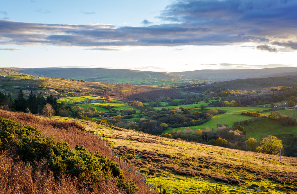
Cleveland Way cliffs from Saltburn over Warsett Hill, with ironstone-mine remains and a charm-bracelet sculpture above the sea.
Huntcliff: A high coastal cliff east of Saltburn bearing the remains of a Victorian ironstone-mine fanhouse, on the Cleveland Way and England Coast Path.
The Cleveland Way: A National Trail that here follows the cliff-top coastline east of Saltburn, also signed as the England Coast Path.
Time: 3h
Lunch: The Ship pub on the Saltburn seafront, early on the route.
Warnings: Cliff-top paths with steep climbs; keep dogs on leads near livestock and cliff edges.
Walk details: Northern Railway (tips, photos, local insights and turn-by-turn directions).

Horden to Hartlepool (Durham)
45 minutes direct from Middlesbrough.

Seaham to Horden (Durham)
45 minutes direct from Middlesbrough.

Sunderland to Seaham (Durham)
45 minutes direct from Middlesbrough.
Danby to Whitby (Yorkshire)
1 hour direct from Middlesbrough.
Recommended: One of the most scenic areas of North Yorkshire, spectacular, truly lovely riverside path. An excellent, scenic rural route through one of the most scenic areas of North Yorkshire, closely following the Esk Valley Path with a lovely riverside path either side of Glaisdale and spectacular views across the Esk Valley west of Sleights. The path can get very muddy in bad weather, there is quite a bit of road walking on quiet lanes and with some occasionally steep and slippery sections. Closely follows the Esk Valley Path and is well signposted. Can easily be split into two sections, Danby to Grosmont and Grosmont to Whitby, using the railway, though the train service is infrequent and refreshment stops are limited, so pre-planning helps.
Time: 8h–16h
Lunch: The choice of refreshment stops is quite limited, especially out of season.
Warnings: The path can very easily get muddy in bad weather, especially between Danby station and Danby Beacon and between Sleights and Ruswarp in winter. Take care crossing the busy A169 at Sleights Bridge and the A171 just outside Whitby.
Walk details: Slow Ways.

Yarm to Stockton (Yorkshire)
15 minutes direct from Middlesbrough.

Darlington to Yarm (Durham)
30 minutes direct from Middlesbrough.

Durham to Chester-le-Street (Durham)
45 minutes from Middlesbrough, with one change.
Amazing views all the way; this gorgeous route. A gorgeous, largely traffic-free rural route reliably walkable year-round, on good ground with limited road walking on quiet lanes. Starts uphill out of Durham; the ground is mostly good but there is quite a lot of tarmac. The sections either side of Finchale Priory are briefly very steep, with a long and steep flight of steps and a footbridge over the river. Largely coincides with other waymarked routes. Finchale Priory is an English Heritage site.
Time: 3h30–6h30
Lunch: There is a cafe at Finchale Priory, roughly midway.
Warnings: The steps down to Finchale Priory are long and steep and can be tricky in wet weather; the quiet roads either side have no pavements and occasional fast cars.
Walk details: Slow Ways.

Blaydon to Newcastle (Durham)
1 hour from Middlesbrough, with one change.
Cracking views along the river. An urban route with a mix of green and built-up spaces, following the banks of the River Tyne and only leaving the river to skirt industrial units. Almost all tarmac or paving and accessible for wheelers and with a minor detour at a stepped railway crossing near Blaydon. A peaceful bridleway start; cracking river views. Follows the Hadrian's Wall National Trail (Hadrian's Way) and the Keelmans Way cycle path along the Tyne, rich in wildlife including the world's most inland kittiwake colony, peregrine falcon and shelduck (best at low tide). Information boards cover the history of industrial Tyneside; the 'Dunston Staiths' timber jetty is visible across the river.
Waterway: three fifths beside rivers and canals.
Time: 2h–4h
Lunch: The Italian bistro Liosi's is on the route; no toilet stops along the riverside.
Warnings: Follows a busy road for a sixth of the walk. Crossing the river at Scotswood Bridge is a little fiddly, walking beside the busy A695 traffic.
Walk details: Slow Ways.

Billingham to Hartlepool (Durham)
15 minutes direct from Middlesbrough.
A lengthy route with substantial pavement sections at the start and end and narrow countryside footpaths in between. The section around Cowpen Bewley Woodland Park is the nicest but also the most challenging terrain. Can be muddy when wet.
Time: 4h–7h30
Warnings: The route crosses the busy A689; the safer crossing point is slightly east of the line shown, at the traffic lights. Can be muddy.
Walk details: Slow Ways.

Darlington to Stockton (Durham)
30 minutes direct from Middlesbrough.

Shildon to Darlington (Durham)
45 minutes direct from Middlesbrough.
Lots of lovely nature and panoramic views. A long route mixing town road-walking with field paths and farm tracks across open country, with panoramic views and lots of nature. Many field paths are poorly maintained, lost or heavily overgrown with nettles and brambles and very wet and muddy after rain. Passes under the A1 near Darlington; there is an ice cream shop at Walworth a short detour off-route.
Time: 5h30–10h30
Warnings: Many field paths are overgrown, lost or blocked and need hacking through nettles; some require detours around farms. Parts cross or run beside the busy A6072 and A1, and the A1 underpass can flood. Tough going for adults and impractical with wheels away from the towns. Can be muddy.
Walk details: Slow Ways.