Walks you can reach from Rochester by train
MapA day hike is just a simple train journey away — plan your next day of green.
Alternatively, view walks directly from Rochester.

Margate to Broadstairs (Kent)
1 hour direct from Rochester.
Beginner-friendly: Just keep the sea on your left and follow it to Broadstairs.
Coastal: almost all along the coast.
Time: 3h–6h
1 lunch spot: the Captain Digby (1h30–3h in)
5 end-of-walk rewards: the Tartar Frigate, the Neptune's Hall, Siam Kitchen, the Magnet Micropub, or the Prince Albert
Warnings: Very popular and busy.
Adapted from: Railwalks.

Chilham to Canterbury East (Kent)
45 minutes direct from Rochester.
Highly recommended
Time: 3h–6h
2 lunch spots: Chilham (30m–1h in) — the Chilham Square, or the Star Inn
5 end-of-walk rewards: the Monument, the Unicorn Inn, the West Gate Inn, the Carpenters Arms, or the Old Buttermarket
Warnings: A fifth urban.
Adapted from: The Rough Guide to Walks in London & the South East (3rd edition).
Similar walk: the Saturday Walkers Club.

Ramsgate to Margate (Kent)
1 hour direct from Rochester.
Recommended: Low chalk cliffs, sandy bays and coves, cliff-top grassland, seaside promenades and historic coastal towns.
Coastal: nine tenths along the coast.
Kingsgate Bay: A chalk-cliff cove on the Thanet coast near Broadstairs, framed by a natural sea arch.
Time: 4h30–9h
2 lunch spots: the Royal Victoria Pavilion (30m–1h30 in), or Forts Café (1h30–3h30 in)
2 end-of-walk rewards: the Mechanical Elephant, or the Cinque Ports
Warnings: Very popular and busy. Check tide timings.
Source: Trains2Green.
Similar walks: the Saturday Walkers Club and Walking Post (inc. GPX).

Canterbury East Circular via Stodmarsh National Nature Reserve (Kent)
45 minutes direct from Rochester.
Flat Kent countryside, arable fields, woods, ancient villages, oast houses, polytunnel farms and riverside.
Walk details: the Saturday Walkers Club (tips, local insights and turn-by-turn directions).

Farningham Road to Eynsford (Kent)
15 minutes direct from Rochester.
Linear middle Darent Valley Path beside the tranquil River Darent, Lullingstone Roman Villa, Eynsford Castle and valley views.
Walk details: Kent Downs National Landscape (tips, photos and local insights).

Farningham Road to Otford (Kent)
15 minutes direct from Rochester.
Ancient woodland, field edges, riverside Darent Valley Path, low hills, chalk downland, quaint villages, golf course and nature reserves.
Time: 5h
Warnings: Motocross path closures possible.
Walk details: the Saturday Walkers Club (tips, local insights and turn-by-turn directions).

Swanley to Sevenoaks (Kent)
30 minutes direct from Rochester.
Linear Darent valley sides on the North Downs Way and Darent Valley Path: three nature reserves including Lullingstone Country Park and Polhill Bank, panoramic Kent Downs views.
Time: 4h30–9h30
Walk details: Kent Downs National Landscape (tips, photos and local insights).

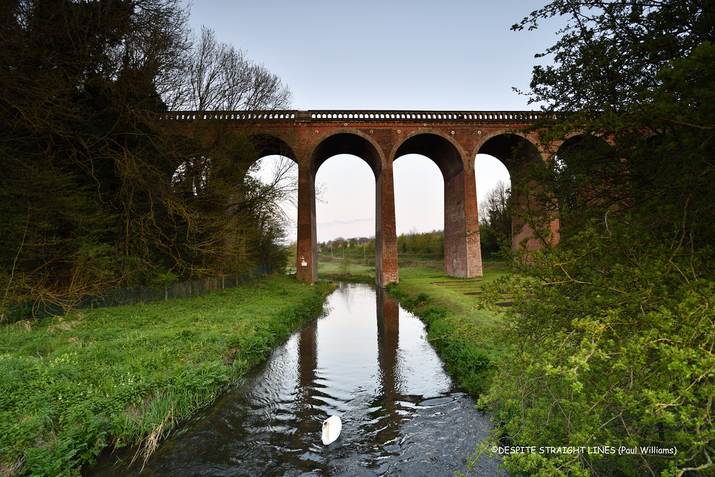
Swanley to Eynsford (Kent)
30 minutes direct from Rochester.
Linear walk into the Darent Valley countryside, with breathtaking views, Lullingstone Roman Villa, the Eynsford Viaduct and the village's humpback bridge and ford.
Walk details: Kent Downs National Landscape (tips, photos and local insights).

Sole Street Circular via the Cobham Park (Kent)
9 minutes direct from Rochester.
Kentish villages, orchards and Cobham Park, past the Darnley Mausoleum, the North Downs Way and historic village pubs.
Hilly: a third on high ground, rising above the surrounding land.
Woodland: two fifths under tree cover.
The Cobham Park: A landscaped Repton parkland surrounding Cobham Hall, with the Darnley Mausoleum.
Darnley Mausoleum: A grand Georgian mausoleum standing within Cobham Park.
Time: 4h–8h
Warnings: Steep climbs; can be quite muddy in winter.
Walk details: Walking Post (tips, photos and local insights).

Meopham Circular (Kent)
15 minutes direct from Rochester.
Chalk grassland, ancient woodland, community woodland, landscaped parkland, wildflower meadows, farm fields, country park and busy road stretches.
The Rochester Castle: A Norman castle beside the Medway with one of the tallest surviving keeps in England.
Time: 4h30
Warnings: Can be muddy.
Walk details: the Saturday Walkers Club (tips, local insights and turn-by-turn directions).
Swanley Circular via Castle Farm (lavender) (Kent)
30 minutes direct from Rochester.
Darent Valley circular with panoramic views, the UK's largest lavender farm at Castle Farm (June/July), 500-year-old veteran trees at Lullingstone Country Park, a Roman villa and a castle.
Walk details: Kent Downs National Landscape (tips, photos and local insights).

Faversham Circular via Uplees Marshes (Kent)
30 minutes direct from Rochester.
Flat marshland, creek embankments, farm fields, quiet country lanes, woodland and tidal waterways.
Time: 4h30
Warnings: Can be muddy.
Walk details: the Saturday Walkers Club (tips, local insights and turn-by-turn directions).