Walks you can reach from Sole Street by train
MapA day hike is just a simple train journey away — plan your next day of green.
Alternatively, view walks directly from Sole Street.

Farningham Road to Eynsford (Kent)
15 minutes direct from Sole Street.
Linear middle Darent Valley Path beside the tranquil River Darent, Lullingstone Roman Villa, Eynsford Castle and valley views.
Walk details: Kent Downs National Landscape (tips, photos and local insights).

Farningham Road to Otford (Kent)
15 minutes direct from Sole Street.
Ancient woodland, field edges, riverside Darent Valley Path, low hills, chalk downland, quaint villages, golf course and nature reserves.
Time: 5h
Warnings: Motocross path closures possible.
Walk details: the Saturday Walkers Club (tips, local insights and turn-by-turn directions).

Swanley to Sevenoaks (Kent)
15 minutes direct from Sole Street.
Linear Darent valley sides on the North Downs Way and Darent Valley Path: three nature reserves including Lullingstone Country Park and Polhill Bank, panoramic Kent Downs views.
Time: 4h30–9h30
Walk details: Kent Downs National Landscape (tips, photos and local insights).

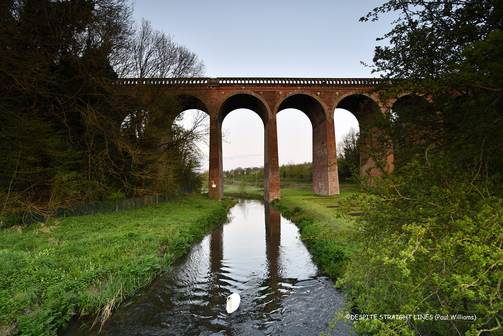
Swanley to Eynsford (Kent)
15 minutes direct from Sole Street.
Linear walk into the Darent Valley countryside, with breathtaking views, Lullingstone Roman Villa, the Eynsford Viaduct and the village's humpback bridge and ford.
Walk details: Kent Downs National Landscape (tips, photos and local insights).

Meopham Circular (Kent)
3 minutes direct from Sole Street.
Chalk grassland, ancient woodland, community woodland, landscaped parkland, wildflower meadows, farm fields, country park and busy road stretches.
The Rochester Castle: A Norman castle beside the Medway with one of the tallest surviving keeps in England.
Time: 4h30
Warnings: Can be muddy.
Walk details: the Saturday Walkers Club (tips, local insights and turn-by-turn directions).
Swanley Circular via Castle Farm (lavender) (Kent)
15 minutes direct from Sole Street.
Darent Valley circular with panoramic views, the UK's largest lavender farm at Castle Farm (June/July), 500-year-old veteran trees at Lullingstone Country Park, a Roman villa and a castle.
Walk details: Kent Downs National Landscape (tips, photos and local insights).

Rochester to Maidstone East (Kent)
9 minutes direct from Sole Street.
Recommended: Gorgeous. A gorgeous, very off-road and quiet route following the River Medway along the Medway Valley Walk, then the North Downs Way and the Augustine Camino before rejoining the river. Well signed throughout and with only a few short bits crossing or going under motorways. Follows the Medway Valley Walk, the North Downs Way and the Augustine Camino. No public transport in the central section, though Aylesford station is about a mile from the village.
Time: 5h–10h30
Walk details: Slow Ways.
Gillingham to Sittingbourne (Kent)
15 minutes direct from Sole Street.
Recommended: Lovely views out over the marshes. A lovely, varied route through woods, fields, gentle hills, orchards and a river estuary, with small sections of mostly safe road walking. The first half is farmland over very gentle hills; the second follows the Medway estuary on the England Coast Trail, with lovely views over the marshes and mudflats. Quite a lot of tarmac and with some muddy parts and slanted cycle gates. The estuary section is on the England Coast Trail. Optional detour along a causeway to 'Horrid Hill'. Break points at Borden, Newington, Rainham, Riverside Country Park and the Strand leisure area.
Time: 5h30–11h
Lunch: Break points with pubs/shops at Borden, Newington and Rainham; cafes and toilets at Riverside Country Park and the Strand.
Warnings: Steps, stiles and gates throughout, plus slanted cycle gates along the estuary. A field path beyond Newington was not reinstated across crops. Care crossing main roads.
Walk details: Slow Ways.

Gillingham to Rainham (Kent)
15 minutes direct from Sole Street.

Gillingham to Queenborough (Kent)
15 minutes direct from Sole Street.
Recommended: The close up views of salt marshes and mud flats of the Medway and Swale, made all the more atmospheric by the distant industrial structures. A long, three-part coastal and estuary route: first a wide, popular path right by the Medway estuary coastline with great views; then field paths and quiet lanes on higher ground with views inland and across the estuary; finally a freshly opened section of the England Coast Path on the Isle of Sheppey. Some informal/permissive paths, deep ruts hidden under long grass and possible high-tide flooding. Uses the England Coast Path. Salt marshes and mudflats are important nesting sites for coastal birds and rare plants. Can be broken at Rainham, Lower Halstow, Iwade or Swale station; the Sheppey line has five stations.
Coastal: three quarters along the coast.
Time: 6h30–13h
Lunch: Toilets and cafes at the Strand in Gillingham and in Riverside Country Park; pubs on Lower Rainham Road; pubs and shops at Lower Halstow and Iwade.
Warnings: The England Coast Path section on Sheppey had unfinished waymarkers and crosses ground with deep ruts hidden under long grass. Some high-tide saltmarsh paths may flood.
Walk details: Slow Ways.

Sevenoaks to Longfield (Kent)
7 minutes direct from Sole Street.
Pretty countryside. A walk through pretty countryside starting on residential roads, then a long valley-floor path, a steep climb up the North Downs escarpment, a series of small steep-sided valleys through pasture and woodland with steep stepped paths. A fair amount of road walking and mostly quiet but with some busier stretches; the going can be soggy and muddy in wet weather. Follows the Darenth Valley Path for much of the early section. Passes alongside Sevenoaks Wildlife Reserve. Can be split using Otford station.
Time: 6h–11h30
Lunch: Otford, midway, has tea rooms and refreshment spots.
Warnings: A steep, stepped climb up the North Downs escarpment and steep stepped descents/ascents at Knatts Valley. Two long road sections are busier than ideal; the road through Hartley is a long grind but has pavements. The route crosses fields with horses near the equestrian centre and across a golf course. Can be muddy.
Walk details: Slow Ways.

Longfield to Swanscombe (Kent)
7 minutes direct from Sole Street.
A mostly quiet route through scenic countryside, with a couple of short, steep footpaths, rutted tracks, at least one kissing gate and a couple of wet, muddy flushes and plus two sections beside busy but well-pavemented roads including the eight-lane A2. Uses the Thames Way in part. Can be cut short at Northfleet station. Skylarks, chalk downland flowers, warblers in the Ebbsfleet Valley reedbeds, and possibly adders in summer.
Time: 3h–5h30
Lunch: A pub and bus stops in Southfleet; a pizza/burger van in the layby north of the A2 bridge and a large supermarket a little further north.
Warnings: Follows a busy road for a sixth of the walk. There are sections beside busy roads including the eight-lane A2, a wide Eurostar-traffic road that is a little dangerous to cross, and a tricky duck-under beneath HS1. The Ebbsfleet footbridge has metal width restrictions.
Walk details: Slow Ways.