Walks from Swanley
MapBeautiful walks starting or ending at Swanley Station.
Alternatively, view walks you can reach directly from Swanley by train.

Swanley to Sevenoaks
Linear Darent valley sides on the North Downs Way and Darent Valley Path: three nature reserves including Lullingstone Country Park and Polhill Bank, panoramic Kent Downs views.
Time: 4h30–9h30
Walk details: Kent Downs National Landscape (tips, photos and local insights).

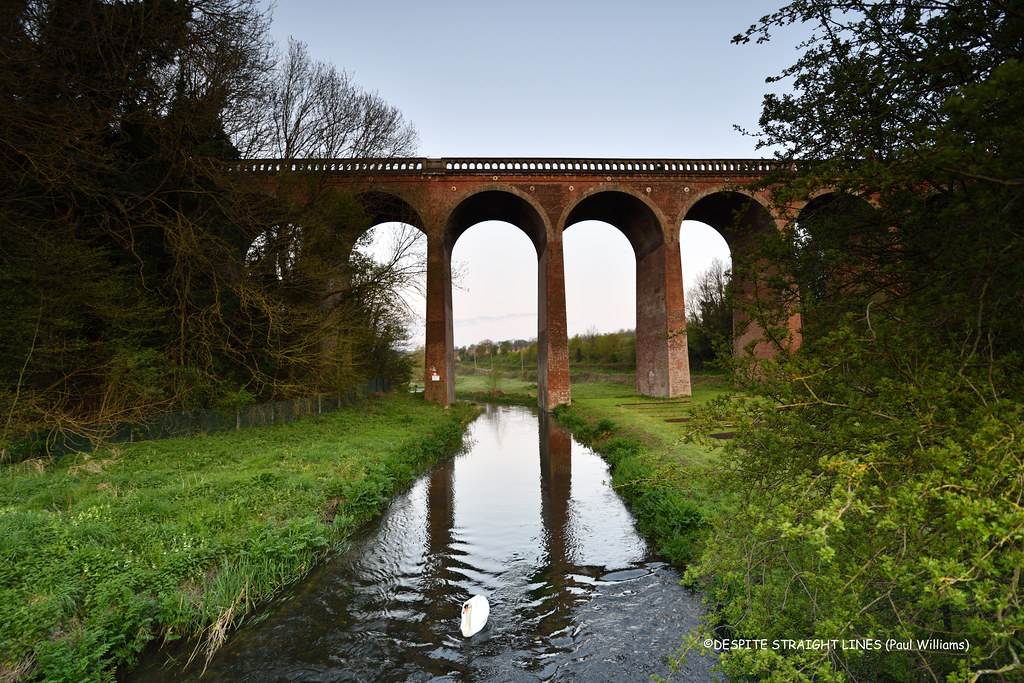
Swanley to Eynsford
Linear walk into the Darent Valley countryside, with breathtaking views, Lullingstone Roman Villa, the Eynsford Viaduct and the village's humpback bridge and ford.
Walk details: Kent Downs National Landscape (tips, photos and local insights).

Swanley Circular via Castle Farm (lavender)
Darent Valley circular with panoramic views, the UK's largest lavender farm at Castle Farm (June/July), 500-year-old veteran trees at Lullingstone Country Park, a Roman villa and a castle.
Walk details: Kent Downs National Landscape (tips, photos and local insights).

Swanley to Longfield
A route avoiding awkward and impassable field sections, climbing a little hill and crossing fields and quiet lanes, with newly planted crop fields (on public rights of way), railway-side stretches, woodland with many paths and residential and light-industrial streets towards the end. Some fields not prepped for walkers; muddy after wet weather. Crosses under the M25 at Button Street. Passes a distinctive tower in South Darenth and bluebells in season.
Time: 3h–6h30
Warnings: Crossing Fawkham Road; the section through Ram's Wood is confusing with many feet-and-wheel paths. Some crop fields where the right of way is unmaintained, so going around is faster.
Walk details: Slow Ways.
Swanley to Dartford
A largely flat, over-70%-off-road walk on field paths along a broad ridge and beside the River Darent on the Darenth Valley Way, through Central Park and the Brooklands Lakes. Some narrow roads, multiple stiles and concrete steps. Underfoot is asphalt and gravel and dirt. Uses the marked Darenth Valley Way. The noise of the A2 and M25 is pervasive around Hawley. Central Park in Dartford has public toilets; possible bus service in Hawley.
Time: 2h30–5h30
Lunch: Near Hawley there is a garden centre cafe, an eat-in bakery and The Chequers pub in Darenth a short way off route.
Warnings: Cross the A225 / Hawley Road straight away heading north, as it soon becomes an uncrossable dual carriageway. Shirehall Road through Hawley is very patchily pavemented. Multiple stiles, some rickety, and a paddock with an electric fence.
Walk details: Slow Ways.

Sidcup to Swanley
An excellent, mostly off-road and very green route through suburban Sidcup, the lovely Foots Cray Meadows (crossing the River Cray at Five Arches Bridge), on into rural country towards Swanley. It crosses Joyden's Wood and field-edge paths past a golf course; the bridleway section of Parsonage Lane and Joyden's Wood can be extremely muddy in winter and with a couple of quiet narrow lanes. Foots Cray Meadows has Five Arches Bridge over the River Cray. Wood-ant nests and bluebells in Joyden's Wood. Birchwood Park golf course restaurant is open to the public.
Time: 2h30–4h30
Lunch: A small parade of shops about half a mile south on the A223, and a farm shop, campsite and pub about the same distance north.
Warnings: The bridleway along Parsonage Lane and the southern edge of Joyden's Wood can be extremely muddy and challenging in winter. A couple of quiet narrow lanes where you may need to squeeze into a nettly verge. At least one stile and small gates. Crossing the busy A223/North Cray Road (a pelican crossing is nearby).
Walk details: Slow Ways.

Orpington to Swanley
A pleasant walk starting and ending with quiet residential streets in Orpington and Swanley, with the peaceful middle section across fields and woods with wild flowers, on tracks that are walking-boot territory in wet weather. Several stiles to cross. Wide views over Kent/London countryside and with Canary Wharf visible in the distance on a clear day. Part of the route follows the Bromley Chelsfield walk and the Windmill Hill Wood Walk.
Time: 2h30–4h30
Lunch: There is a pub and a post office just off route in Crockenhill, and a Tesco and other shops in Orpington at the start.
Walk details: Slow Ways.