Walks you can reach from Longfield by train
MapA day hike is just a simple train journey away — plan your next day of green.
Alternatively, view walks directly from Longfield.

Farningham Road to Eynsford (Kent)
4 minutes direct from Longfield.
Linear middle Darent Valley Path beside the tranquil River Darent, Lullingstone Roman Villa, Eynsford Castle and valley views.
Walk details: Kent Downs National Landscape (tips, photos and local insights).

Farningham Road to Otford (Kent)
4 minutes direct from Longfield.
Ancient woodland, field edges, riverside Darent Valley Path, low hills, chalk downland, quaint villages, golf course and nature reserves.
Time: 5h
Warnings: Motocross path closures possible.
Walk details: the Saturday Walkers Club (tips, local insights and turn-by-turn directions).

Swanley to Sevenoaks (Kent)
9 minutes direct from Longfield.
Linear Darent valley sides on the North Downs Way and Darent Valley Path: three nature reserves including Lullingstone Country Park and Polhill Bank, panoramic Kent Downs views.
Time: 4h30–9h30
Walk details: Kent Downs National Landscape (tips, photos and local insights).

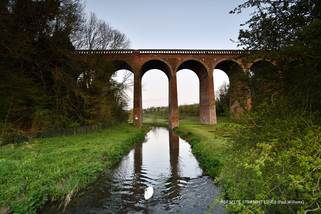
Swanley to Eynsford (Kent)
9 minutes direct from Longfield.
Linear walk into the Darent Valley countryside, with breathtaking views, Lullingstone Roman Villa, the Eynsford Viaduct and the village's humpback bridge and ford.
Walk details: Kent Downs National Landscape (tips, photos and local insights).

Meopham Circular (Kent)
4 minutes direct from Longfield.
Chalk grassland, ancient woodland, community woodland, landscaped parkland, wildflower meadows, farm fields, country park and busy road stretches.
The Rochester Castle: A Norman castle beside the Medway with one of the tallest surviving keeps in England.
Time: 4h30
Warnings: Can be muddy.
Walk details: the Saturday Walkers Club (tips, local insights and turn-by-turn directions).

Sole Street Circular via the Cobham Park (Kent)
6 minutes direct from Longfield.
Kentish villages, orchards and Cobham Park, past the Darnley Mausoleum, the North Downs Way and historic village pubs.
Hilly: a third on high ground, rising above the surrounding land.
Woodland: two fifths under tree cover.
The Cobham Park: A landscaped Repton parkland surrounding Cobham Hall, with the Darnley Mausoleum.
Darnley Mausoleum: A grand Georgian mausoleum standing within Cobham Park.
Time: 4h–8h
Warnings: Steep climbs; can be quite muddy in winter.
Walk details: Walking Post (tips, photos and local insights).
Swanley Circular via Castle Farm (lavender) (Kent)
9 minutes direct from Longfield.
Darent Valley circular with panoramic views, the UK's largest lavender farm at Castle Farm (June/July), 500-year-old veteran trees at Lullingstone Country Park, a Roman villa and a castle.
Walk details: Kent Downs National Landscape (tips, photos and local insights).

Faversham Circular via Uplees Marshes (Kent)
45 minutes direct from Longfield.
Flat marshland, creek embankments, farm fields, quiet country lanes, woodland and tidal waterways.
Time: 4h30
Warnings: Can be muddy.
Walk details: the Saturday Walkers Club (tips, local insights and turn-by-turn directions).

Farningham Road to Sole Street (Kent)
4 minutes direct from Longfield.
Urban sprawl, housing developments, busy roads, arable fields and occasional glimpses of historic rural Kent.
Walk details: the Saturday Walkers Club (tips, local insights and turn-by-turn directions).

Rochester to Sole Street (Kent)
15 minutes direct from Longfield.
Dickensian Kent and the Medway: Rochester's cathedral and castle, then Ranscombe Farm and Cobham Park to Sole Street.
Woodland: a fifth under tree cover.
The Rochester Cathedral: England's second-oldest cathedral, founded in 604, in the heart of Rochester.
The Rochester Castle: A Norman castle beside the Medway with one of the tallest surviving keeps in England.
The Ranscombe Farm Reserve: A nature reserve near Rochester protecting rare arable wildflowers on the Kent downs.
The Cobham Park: A landscaped Repton parkland surrounding Cobham Hall, with the Darnley Mausoleum.
Time: 3h30–7h
Walk details: Walking Post (tips, photos and local insights).

Teynham to Faversham (Kent)
45 minutes direct from Longfield.
Flat orchards and fruit farms, tidal river seawall, coastal creeks, mudflats, salt marshes, drainage ditches, dykes, windswept grazing marshes and historic market town streets.
Time: 5h30
Warnings: Can be muddy.
Walk details: the Saturday Walkers Club (tips, local insights and turn-by-turn directions).

Faversham to Whitstable (Kent)
45 minutes direct from Longfield.
Easy coastal walk, flat terrain, seaside villages and open shoreline.
Coastal: three quarters along the coast.
Time: 3h30–7h30
Walk details: the Saturday Walkers Club (tips, local insights and turn-by-turn directions).